uNext
Accurate surveys and fast 3D reconstruction of the underground utility network

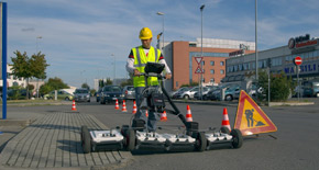
The uNext platform offers an all-in-one, non-invasive utility detection software solution which exploits advanced technologies and methodologies. This software, 100% developed by IDS GeoRadar, is based on the Opera Duo and DS2000 Ground Penetrating Radars (GPR) leveraging data quality and intuitiveness for improved utility detection and mapping.
uNext is designed to operate directly on-site, to maximize user experience. Moreover, the solution is fully compatible with Leica Geosystems’ DX Manager software, allowing for data storage and cloud data sharing.
uNext software is available in a Basic and Advanced Version.
uNext Basic Software Platform
The uNext Basic Version features include:
•Compatibility with any GNSS and/or TPS: Provides a seamless interaction to IDS GeoRadar, Leica Geosystems, and any other positioning sensor, to provide the best geographical positioning of multiple utility targets in a very short time.
• Integration with Cable locators: Quickly and easily integrate information on cable and pipe positioning. Users can benefit from an integrated view of GPR and EML data.
• Survey Reports: Export survey reports including extracted maps and targets directly in the field.
• Data export to CAD/GIS: Export the identified targets to CAD or GIS maps for professional SUE/utility mapping.
• Cartographic Imports: Import the cartography of the surveyed area from different sources and visualize geo-referenced underground asset position in real-time.
uNext Advanced Software Platform
The uNext Advanced platform leverages all the functionalities of the uNext Basic software, providing additional features:
• Radar Tomographies processing: Creates an even more accurate, faster 3D reconstruction of the underground utility network and merge this information with any existing cartographies. On-site processing of radar tomographies to ease the interpretation of results.
• Assisted Pipe Tracker: Detects a pipe or cable once and the software automatically maps the exact position of the utility over the surveyed area. Users can benefit from more accurate, reliable data and perform data acquisitions more productively, and in a shorter amount of time.
• Data Re-processing: In addition to on-site data acquisition and processing features, users can re-process rough radar data to ultimately optimize data processing as well as customize data visualization with filtering capabilities. The uNext platform is continually developed by our R&D department. More features will be available to everyone as part of new software releases.
•Provides Cloud Software Integration: Export, store, share, and access data on major Cloud service providers for a streamlined workflow in utility detection.


