Utility Mapping and Detection
IDS GeoRadar offers a full range of non-intrusive utility detection and mapping products which exploit the most advanced ground penetrating radar technologies and methodologies. Whether it is for a water company considering a major new investment or an engineering company looking to reduce costs, such technology offers vital information on subsoil conditions providing reliable data to assess safety conditions and avoid potential danger and risks. Lack of knowledge of subsoil conditions has lead to numerous, often fatal, accidents most commonly caused by utilities rupturing during excavation, pipe corrosion/deterioration and for geologic reasons (Source: The Federal Laboratory Consortium for Technology Transfer, U.S. Department of Transportation and the U.S. Geological Survey reports).
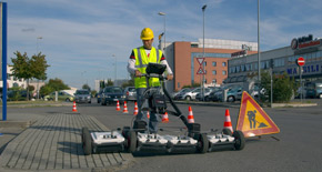
Stream UP, Stream DP, Opera Duo, RIS MF Hi-Mod - IDS GeoRadar Utility Mapping & Detection product range.
Increasing productivity, quality and minimizing costs are IDS GeoRadar priorities to guarantee successful results. The IDS GeoRadar consultative approach allows you to proceed with confidence, keeping your workers safe, avoiding delays and offering an accurate estimate of costs associated with underground improvements.
Browse the product section to see what IDS GeoRadar offers or contact us at sales.geo@idsgeoradar.com
IDS GeoRadar Utility Detection & Mapping Services
- Real time detection of buried utilities (pipes, cables, etc.) for excavation planning and damage avoidance;
- Utility relocation design, coordination and cost estimates;
- Pipes and cables location on CAD maps;
- Communication of utility data to concerned parties;
- Subsurface Utility Engineering.
IDS GeoRadarUtility Detection & Mapping - Key Benefits
- Consolidated complete procedure to create detailed digital mapping of underground utility lines in CAD and GIS platform;
- Extensive utility mapping with several products carried by vehicles which offer fast and reliable surveying of large road and offroad areas;
- Multi-frequency, multi-channel technology – IDS GeoRadar is the first company to offer multi-frequency array solutions;
- Competitive Rates – IDS GeoRadar provides cost effective solutions using cutting-edge technology and experienced personnel located worldwide;
- Expertise – IDS GeoRadar boasts highly-qualified technicians to help you design a specific solution for your requirements. A dedicated sales team is always on hand to offer technical expertise for customer needs;
- Flexibility – IDS GeoRadar control unit is designed to work with all IDS GeoRadar antennas guaranteeing easy upgrade or implementation of other IDS GeoRadar ground penetrating radar solutions avoiding substantial additional costs.


