


RockSpot
Locating, tracking and notifying on rockfalls

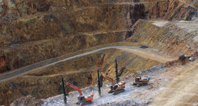
RockSpot is an innovative radar system able to locate, track and notify on rockfalls. It’s the industry’s first end-to end solution able to trigger notifications on rockfalls and create a full rockfall database to maximize rockfall hazard management. RockSpot never sleeps providing continuous monitoring night and day filling the gap in critical monitoring in mining.
Events database for improved risk mitigation and planning
RockSpot acts as a 24/7 rockfall reporter. Rockfalls are tracked, stored and automatically classified in an events database to perform data analysis with multiple statistical tools: exploring custom defined areas and single falling events in detail. RockSpot supports an efficient rockfall risk zonation, TARP fine tuning and back analysis to reduce operational and geotechnical risks.
Real-time notifications for in sync risk management
This compact and powerful radar picks up falling rocks in near to real time and working crews receive prompt notification for action along with immediate access to all event’s details. With an external long-running energy solution, users can depend on 24/7 monitoring coverage for safety.
Integrated monitoring solution with GeoCloud
Users can access RockSpot data from the innovative GeoCloud platform, a web-based application. Optimised for mobile devices, GeoCloud provides immediate access to all important data relative to the rockfall events. All slope movements are georeferenced and overlaid on site map and multiple statistical tools consent an advanced customizable data analysis of rockfall events.


FEATURES AND BENEFITS
- 24/7 monitoring and tracking of rockfalls
Real-time notifications upon rockfalls and creation of a complete events database
- Long range and high precision for full coverage
A single radar unit can cover an entire wall with high resolution
- Powerful software to get more out of data
Availability of multiple statistical tools to analyze the collected data for cost reductions in mitigation measures - Durable design and low maintenance
Clean design lowering maintenance costs and enabling it to operate in the harshest environments. - Georeferencing and Real-time streaming
Georeferenced data and a built-in camera providing streaming video of the monitored area
All RockSpot systems are controlled by GeoCloud, available both on cloud and on-premises. GeoCloud provides an easy and immediate access to all important data relative to the events georeferenced and overlaid on the site map. Users can explore RockSpot’s collected data with this web-based application platform, optimised for both mobile device and desktop usage.
Multiple statistical tools consent to manipulate the events database and plot custom-charts based on user defined areas (event rate, duration/area extension, velocity, run out distance) for a comprehensive back analysis, models calibration, integrity of rockfall controls and design change justification.
To complete the information, an integrated livestreaming camera provides continuous imagery of the monitored area. The radar map is available in GeoCloud along with all the relevant statistics.

Contact IDS GeoRadar
Contact our sales team and get detailed information about IDS GeoRadar products and services.
Contact our sales team and get detailed information about IDS GeoRadar products and services.
