Camera Kit
The one and only advanced integrated solution for Utility Detection surveys

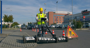
The new camera kit supplied by IDS GeoRadar for its world-renowned GPR Opera Duo represents the all-in-one, smart solution to take utility detection to the next level.
An easy click is enough to insert the camera (even on Opera Duo you already have) and to start carry out clearer and faster surveys!
With the camera kit installed on your Opera Duo, real and virtual world are now directly linked.
In fact during acquisition phase the grid on the camera guide you in the scanning to do parallel scans and furthermore the software generates automatic and referenced documentation to support the survey.
During data processing phase the camera is useful to associate surface evidences with underground assets.
The selling price includes the camera kit and 1-year uNext subscription!
Main features include:
- Reduced Acquisition Time– No more time wasted both during acquisition and data analysis phases.
- Post-scanning analysis – Re-elaborate the acquisition like you were on site!
- Documentation automatically produced – The proof of the acquisition is suddenly available and shareable with anyone.
- Surface data combined with detection data – Detect an underground utility and immediately associate it into surrounding environment.
- Over-impressed grid– Helpful to do parallel scans.
The uNext platform offers an all-in-one, non-intrusive utility detection software solution which exploits the most advanced technologies and methodologies in the market.
100% developed by utility market leader IDS GeoRadar, the uNext platform is based on the Opera Duo and DS2000 Ground Penetrating Radars (GPR) leveraging, data quality and intuitiveness for unparalleled utility location and mapping.
The uNext platform is designed to operate directly on site maximizing user experience. Moreover, the solution is fully compatible with Leica Geosystems’ DX Manager software allowing for data storage and sharing in the cloud.
uNext Basic leverages:
- Any GNSS and/or TPS – seamless interface to IDS GeoRadar, Leica Geosystems and any other positioning sensors to provide the best geographical positioning of multiple utility targets – in a very short time.
- Cable locators – to quickly and easily integrate information on cable and pipe positioning. Users can benefit from an integrated view of GPR and EML data.
- Survey Report – to export survey reports including extracted maps and targets directly in the field.
- CAD/GIS – to transfer the identified targets to CAD or GIS maps for professional SUE / utility mapping.
- Cartography– to import the cartography of the surveyed area from different sources, and visualise geo-referenced underground asset position in real time.
The uNext Advanced platform leverages all the functionality comprised in the uNext Basic software. Moreover, it offers:
- Tomography – to create an even more accurate, faster 3D reconstruction of the underground utility network and merge this information with any existing cartographies. On site processing of radar tomographies to ease theinterpretation of results.
- Assisted Pipe Tracker – to detect a pipe or cable once and automatically have the software map the exact position of the utility over the surveyed area. Users can benefit from more accurate, reliable data and perform data acquisitions more productively, and in a shorter amount of time.
- Data re-processing – In addition to on-site data acquisition and processing features, users can re-process roughradar data to ultimately optimise data processing as well as customise data visualisation with filtering capabilities.
- Cloud Software Integration - Export, store, share and access data on major Cloud services providers for a streamlined workflow in utility detection.
The uNext platform is continually developed by our R&D department. More features will be avaliable to everyone as part of new software releases.


