C-thrue XS
The compact hand-sized GPR with dual polarization to never miss a detail in one scan

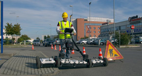
Construction and service companies together with civil and structural engineers can improve their safety by using C-thrue XS to quickly locate rebars, voids, post-tension cables, cavities, conduits, and any other objects buried in the structure before cutting or drilling into the concrete.
C-thrue XS, adding to the C-thrue product family, is the new compact hand-sized GPR with dual polarization to never miss a detail in one scan: the smallest and lightest antenna on the market capable of detecting both shallow and deep targets.
DUAL ANTENNA POLARIZATION: DETECT SHALLOW AND DEEPER TARGETS IN A SINGLE MOVE.
C-thrue XS allows the most accurate scanning performance and real-time analysis of concrete structures with a hand-sized device able to perform in-depth inspections. C-thrue XS boasts a dual polarization radar technology (displaying both HH a VV channels), making this device capable of locating and identifying shallow and deep targets in a single swath with the maximum clarity of data leading to an optimal decision making.
MULTIPLE CONFIGURATIONS: STAND- ALONE OR INTEGRATED USE
Offering the maximum flexibility, C-thrue XS is available in two configurations:
- STANDALONE: Easily scan across any concrete inspection scenario with C-thrue XS and promptly visualize the collected data results on your tablet
- INTEGRATED USE WITH C-THRUE: C-thrue XS’ combined use with C-thrue allows to cover any jobsite challenge and quickly visualize data on C-thrue’s multi-touch display
A compact and light telescopic pole and an external controller allow C-thrue to maximize its reach in concrete scanning operations across challenging locations: under a deck, along vertical walls or ceilings. C-thrue can also be used in combination with C-thrue XS - the smallest and lightest concrete scanning antenna on the market – to inspect constricted and difficult to reach spaces: pillars, corners and areas around obstructions.
EsT | Equalized scrambled Technology (等化スクランブル技術)
EsT テクノロジーは、アンテナの放射性能全体を利用して GPR 信号を完全に制御することができ、最高のノイズ除去を行い、低周波と高周波の両方を捕捉して、深度範囲の拡大と高分解能を実現し、ユーティリティ探査の新たな可能性を提供します。
IDS GeoRadar が特許を取得したこの革新的な技術は、これまで達成できなかった GPR 性能を提供し、今まで深度範囲と分解能のどちらか一方でしか対応できなかった埋設物の位置特定を、深度範囲と分解能の両方にて行うことができるようになりました。EsT テクノロジーにより、Stream DP は、市場で入手可能な他のソリューションと比較して、より深いレンジで地下資産を最大限に検出する比類のない GPR 性能を提供することができます。
C-thrue XS - Advanced GPR software to process data on-site
C-thrue XS’s data collection remote desktop software allows to promptly visualize results directly on the field on a connected laptop or on C-thrue’s multitouch display.
The software is specifically developed and suitable for in the field analysis:
- Automatic system calibration for an easy and quick set-up and start;
- Automatic recognition of rebars and voids in concrete structures;
- Digital on-site representation of data and targets through Augmented Reality;
- Real time visualisation of 3D radar tomography;
- Real time data sharing enabling double data visualisation and high resolution imaging both on product display and remote desktop connection to external device;
- Capability to mark targets within the software;
- Fully integrated with NDT Reveal post-processing software;
- Ability to export full survey report.
NDT Reveal - Advanced GPR processing and imaging software
NDT Reveal is the professional CAD-based post-processing GPR software to analyze data collected with C-thrue and C-thrue XS devices. NDT Reveal software platform enables users to organize and share GPR data results for a comprehensive analysis of concrete inspections. With NDT Reveal users are able to:
- Manage different projects from different jobsites and locate GPR jobsite surveys on CAD files
- Display 2D and 3D GPR data and insert features (e.g. rebars, post tension cable voids and drill areas)
- Use tomographic map views (C-Scan) including radar scan fusion;
- Perform advanced targeting using radar-scan and tomographic view.
- Produce digital exports: DXF and DWG format
- Create job site reports with 2D and 3D GPR data of detected items, photos, sketches and CSV tables
C-thrue brochure
C-thrue datasheet
C-thrue Video - Behind the Name!
C-thrue Product Video - See Thru Concrete Structures and Reveal True Data that Lead to Optimal Decision-Making
Automatic position and navigation system (Virtual Pad) increases productivity and reduces survey times
No limitations to your analysis thanks to a telescopic pole for maximum flexibility
Augmented Reality: takes concrete structure analysis to next level!
A new compact and transportable kit to work everywhere!
C-thrue XS Video
The smallest and lightest antenna on the market capable of detecting both shallow and deep targets.
The smallest and lightest antenna on the market capable of detecting both shallow and deep targets.


