Aladdin
3D Ground Penetrating Radar for concrete inspection

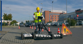
A patented survey kit, Aladdin enables the acquisition of 3D images with the highest resolution. Halving acquisition time, this GPR reveals shadowed and deep targets with its full-polar antenna. The Aladdin has many surveying abilities, including:
- 3D imaging of shallow and deep rebars in concrete;
- Inspection of concrete for location of voids;
- Inspection of concrete thickness, integrity;
- 3D imaging of pre-tension and post-tension cables;
- Inspection and analysis of old structures and monuments;
- Inspection of walls and floors for the location of pipes, objects, caches, etc..
The Aladdin features:
- Dual Polarized: Aladdin is equipped with two 2GHz antennas polarized perpendicular to each other. The dual polarization enables deeper surveying, providing images of both shallow and deep structures. Standard antennae read shallow targets (rebars), but do not reveal lower structures.
- Wi-Fi link: For ease of operation when data collection is required in awkward locations such as vertical walls or rooftops.
- Immediate 3D imaging in the field: With just the press of a button, the 3D tomography of the surveyed area can be available in real time in the field.
- Pad Survey Guide (PSG): Patented survey kit that permits the acquisition of 3D images with the highest resolution.
- Special full-ploar high frequency: A 2 GHz antenna combined with the patented PSG permit joint orthogonally polarized scans to be acquired in a single pass. This detects shallow and deep structures, halving acquisition time compared to standard methods.
Other benefits of the Aladdin include:
- Faster surveys: dual polarization allows scans to be performed in just one direction, halving acquisition time;
- Able to penetrate below the first level of rebar with the dual polar antenna;
- High resolution 3D imaging;
- Extremely flexible user operations with wireless link and a light easily transportable system;
The Aladdin system is suitable for in the field analysis of concrete. Aladdin is equipped with K2 FastWave acquisition software. A dedicated button provides a tomographic view of the subsurface to cut the surface.
K2 FastWave
The software comes with comprehensive tools to customise the acquisition parameters and calibrate the signal of every acquisition channel.
Achieve the best result from the survey by mixing longitudinal and transversal scan in the post processing with K2 FastWave’s dedicated tool to collect data in grid mode. At the end of the acquisition, the software processes data by linking to the GRED 3D software, which is used for the data interpretation.
GRED HD 3D - Advanced GPR processing and imaging software
An advanced post processing software for 3D and tomographic rendering of acquired data, GRED HD 3D is recommended for pipe and utility mapping and 3D analysis of the subsurface.
The software presents a 3D view of the subsurface, with a complete set of options to navigate, cutting and marking anomalies. GRED HD 3D is also able to export 2D plan-view slices of the subsurface from which you can best interpret anomalies and pipes.
The pipes and cables detected can be marked with a dedicated tool. Specify a color for each pipe, mark the depth of each and an estimate the dimensions. The marked pipes can then be visible in the 3D view, the 2D tomography slice and the traditional radargram.
Enhance the capability of the interpretation when you show multiple radargrams simultaneously.


